


le garn

losjo
Utilisateur
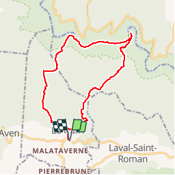

Longueur
16,6 km

Altitude max
404 m

Dénivelé positif
591 m
Km-Effort
25 km

Altitude min
56 m

Dénivelé négatif
591 m
Boucle
Oui
Date de création :
2014-12-10 00:00:00.0
Dernière modification :
2014-12-10 00:00:00.0
7h54
Difficulté : Moyen

Application GPS de randonnée GRATUITE
 SityTrail
IGN / Instituts géographiques
SityTrail Plus
Le monde est à vous
À propos
Randonnée Marche de 16,6 km à découvrir à Occitanie, Gard, Le Garn. Cette randonnée est proposée par losjo.
Description
moyenne
Localisation
Pays :
France
Région :
Occitanie
Département/Province :
Gard
Commune :
Le Garn
Localité :
Unknown
Départ:(Dec)
Départ:(UTM)
617548 ; 4906559 (31T) N.
Commentaires
cool